I am enchanted by water trickling out of the earth. Perhaps it is primordial, this deep evolutionary connection terrestrial animals have to water, a calling back to the first element. Or perhaps it is simple poetry — these two disparate elements, earth and water, one all solid and form, the other shapeless and incorporeal, mingling below sight. We walk as though at its surface the Earth is solid, but it is not. In reality it is rotted bedrock and loose sediments mixed with decayed organic matter. It is full of hidden voids and channels where shapeless water easily infiltrates. The interface of earth and water creates a dynamic dance. In this zone of essential elements, water seeps into the porous earth, finding what paths it can, filtering down through humus and loam, sand and stone. When the path is blocked by hard rock or high water, it flows sideways. And then, where the water permeates high, it reappears as a spring seeping out of the hillside.
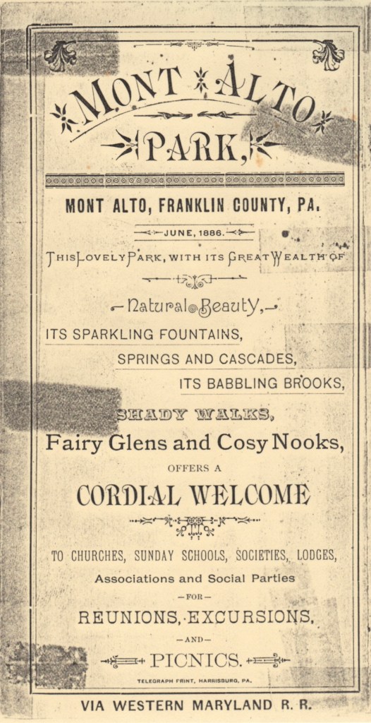
It is a cold and sunny January day, and I have traveled to the Michaux State Forest to find Tarburner Spring. I first read about this geological feature while doing historical research on Pennsylvania’s South Mountain thirty years ago. In the 19th century iron companies owned most of South Mountain. As a way to diversify their revenue they developed private parks for townspeople to take mountain excursions. Tarburner Spring was located at the top of a particularly arduous hike called The Ramble in a park owned by the Mont Alto Iron Company. While many of the park amenities were easily accessible, this spring was high on the mountain and visiting it required effort. It evoked a more primitive time when tar burners, men who would cook pitch from pine logs and reduce it to tar, camped there in season. Historic descriptions of the spring have long captured my imagination, but I have never seen it for myself. My adventure today is to connect this historical impression with the contemporary landscape.
Although Tarburner Spring has lived long in my imagination, it is not a mythical fountain. A map of South Mountain locates the spring at 1800 feet above the Atlantic Ocean, on a west facing slope a few miles east of the Borough of Mont Alto. The spring sits in the heart of a mountain which has irregular ridges and hollows created by multiple tectonic upheavals, varying bedrock, and millions of years of weathering. South Mountain is the 70- mile long northern end of the Blue Ridge Mountains, which itself is a province of the 1500-mile long Appalachian Mountains. It extends northward from Knoxville, Maryland, and reaches 50 miles into South Central Pennsylvania before tumbling into a field of giant boulders at the edge of the Yellow Breeches Creek near the town of Dillsburg. Like the rest of the Blue Ridge Province, South Mountain creates a knobby, but well drained, landscape.
My delay in finding Tarburner Spring doesn’t come from a mysterious location but rather from being out of the way. Like it was in 1880, you have to put some effort in — seeing it requires an intentional trip.
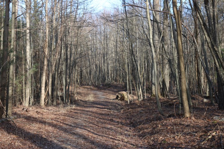
This is what has me driving on the Lincoln Highway into the mountain west of Gettysburg. I turn south at the remains of Thaddeus Stevens’s Caledonia Ironworks, which Confederate soldiers burned down in 1863 in retribution for his antislavery stance. Taking hairpin mountain roads, I track one run up only to follow another down. The paved thruway veers west down to the Borough of Mont Alto, but I turn east onto a gravel state-forest road. At the intersection the water utility has a chain link fence around sizable covered ponds collecting mountain spring water. The road heading up the mountain is desolate in January. My meandering climb roughly tracks a stream called Red Run. After several miles, I approach the ridgetop where I come upon a dirt maintenance road barred by a rusted gate. Without a key this is as far as the truck will take me.
I set off on foot. The road is level running parallel to the ridge. The ground is frozen underfoot, and the frost has built up miniature castles of crystalline ice and mud where wheel ruts held puddles the day before. There is a light breeze whispering through the bare branches as I crunch along. A half mile in, a drainage channel meets the track from the hillside, but it is small and dry — only an intermittent stream runs here. I continue on a mile farther and find a landscape clue: a small, steady run of water cutting a gully in the earth. The nascent ravine is several feet deep; big enough to get under the dirt road through a corrugated metal culvert. This is the same Red Run, a permanent stream that feeds Antietam Creek, the Potomac River, and the Chesapeake Bay. Turning upstream to find the source, I need to follow the course only a few hundred yards to Tarburner Spring.
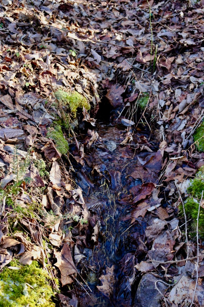
Despite the frozen air, water runs out of Tarburner Spring clear and steady. Leaves that hung in the canopy in summer, shading the cool spring, lie brown and grey on the forest floor. There has been no heavy, wet snow yet to pack them into a soggy mat — the first step in becoming part of the soil. The diverse trees that compose the mixed hardwood forest are represented: tulip poplar, maple, hickory, and various oaks. Even on a frozen January day, Tarburner Spring issues from a small cleft in the mountain. You could fill a canteen with spring water in a few seconds. The flow is strong enough to create the beginnings of a streambed. It has washed out smaller bits of sand and soil. The bottom is lined with small, rough pebbles that have broken off of the ancient mountain. Bare white roots from the forest flicker like filaments caught fast between upstream and downstream. Leaves have lodged in the water and turned up a slick russet side. Life clusters around the water and the relative warmth that emanates from underground. Within one stride, Tarburner Spring has green mosses clinging to the edge of its channel. A seedling hemlock begins to shade the stream. Nearby, wintergreen shoots poke through the leaf litter, appearing small but connected tightly to each other and the hidden forest belowground. The thorny whip of a greenbriar tries to snag a niche in the shady woods.
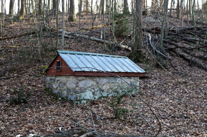
Tarburner Spring sits a couple hundred feet below a sandstone ridge. The west-facing slope levels into a shelf fifty feet across right where the spring emerges. In January, there is a single clear stream issuing from the earth, although abundant evidence indicates in wetter months this is a soggy field of springs. Even now there are wet puddles in the leaves where slow seeping occurs. With vernal melt and April rains, this terrace will become saturated, and the flow coming out of Tarburner will go from dependable pour to robust flush. Someone over the years, most likely from the Bureau of Forestry, built two small spring houses on the terrace.
Tarburner Spring is noteworthy in particular because it had an evocative name and was advertised as a remote destination for excursionists a hundred and forty years ago. But there are dozens of springs much like this one up and down the spine of South Mountain. This is the place on a landscape where rivers begin and this mountain splits its water between the Susquehanna and the Potomac Rivers. I have always considered “headwaters” to be a propitious word. The beginning of water. Although water is described as renewable, an endless cycle, this is the place the story begins. A small spring the width of one hand flows downhill gathering mass and momentum as it becomes a creek and then a river, which not only shapes the physical landscape, but also provides water necessary for human cities and industries — in sum civilization. In the realm of economics, we say that water supply is an important landscape service of forested mountains. And in fact, that is one strong motivation for protecting South Mountain today, because the water only runs clear and clean if the forests and soils are intact. Where they are, the mountain is a sponge that releases a steady flow. Water trickling out of the earth, on a remote mountaintop, is a small process happening largely out of sight, yet of such great import.
