A gas pipeline buried next to your house is like the snake in the woodpile. You know it’s there. But you don’t go digging around. And you hope it behaves.
A tangled web of infrastructure crosses our landscapes and plays a big role in how they form and function. Infrastructure is indispensable, formative, and intrusive. It comes in many types. No city exists without it. No modern economy runs without its services. Some infrastructure, like water mains or traffic lights, enables cities to operate, while connective infrastructure lashes city to city and region to region.
I live in a new mixed-use development. Fellow planners would euphemistically call it a “traditional neighborhood development,” but there isn’t actually anything traditional about it. Five years ago, instead of hundreds of houses and apartments, there was cow pasture and cornfield. Real tradition here would require livestock on the brand new village green.
In the modern world, engineers’ intrusions are legacies we all live with and around. Sometimes infrastructure muscles into the city — boring under buildings or, worse, plowing down neighborhoods and paving over parks.
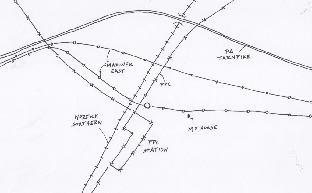
In my neighborhood, the connecting infrastructure was here long before my townhouse sprouted. A defining characteristic of the South Central Pennsylvania landscape is the historic importance of logistics. Canals, then railroads, then highways took advantage of the geography. We are a crossroads between busy Atlantic ports and the rich Trans-Appalachian West, what the noted conservationist and planner Benton MacKaye called the Inland Empire. It is not surprising that new suburbs in this landscape squeeze in around well-entrenched infrastructure. A fifteen-minute walking tour around my neighborhood illustrates the tangled web of infrastructure that shapes and connects landscapes.
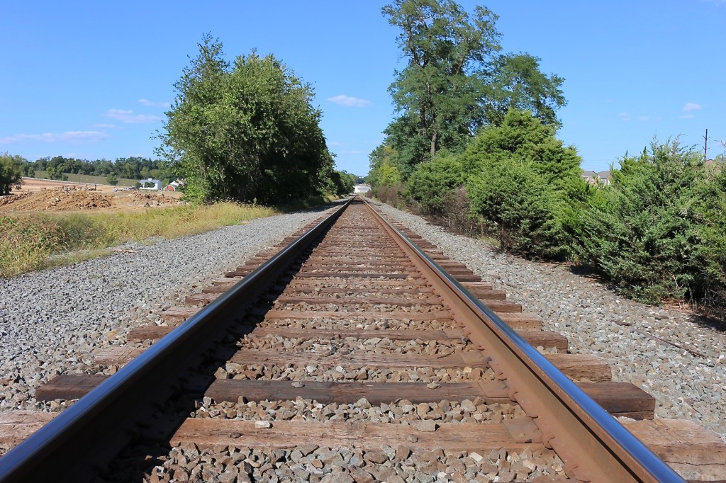
The Pipeline
Pipelines are nearly invisible infrastructure. Several lie buried thirty feet beyond my front gate. A planted wildflower meadow dresses the right of way while yellow plastic pylons trace their path.
The first Mariner East pipeline was built in 1931 and ran under rural fields and pastures. For 85 years it shipped gasoline from refineries at Marcus Hook on the Delaware River across the state through an eight-inch pipe.
Technology and economies define resources. When they change, how we value resources changes. Hydraulic fracturing, more commonly known as fracking, now exploits natural gas that has been trapped in the Marcellus and Utica shale formations of the Allegheny Plateau for tens of millions of years. In 2015, engineers reversed and renamed Mariner East 1 so natural gas liquids could begin flowing east.
But the old pipe isn’t nearly big enough, so another 8-inch pipeline, Mariner East 2, has been under construction for four years. That will still not big enough, so a parallel 16-inch pipeline, Mariner East 2x, is also being built. When we moved in three years ago the work was going on in our front yard and proceeded for another 18 months. When completed end-to-end these pipelines will carry more than a half a million barrels a day of butane, propane, pentane, and ethane. The petrochemical river from the Inland Empire to industries and ports on the Delaware River flows thirty yards from where I lay my head every night..
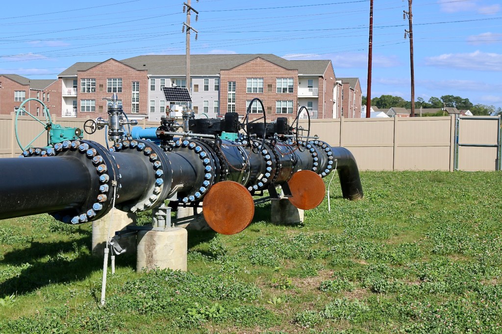
As long as nothing goes wrong, the pipelines have limited impact on the landscape — sinkholes, leaks, and explosions are rare. In the woods nearby there is the telltale sign of a cleared corridor, but here, through the suburbs, we have just a curious parade of yellow pylons marching over the hills with the occasional artificial wildflower meadow.
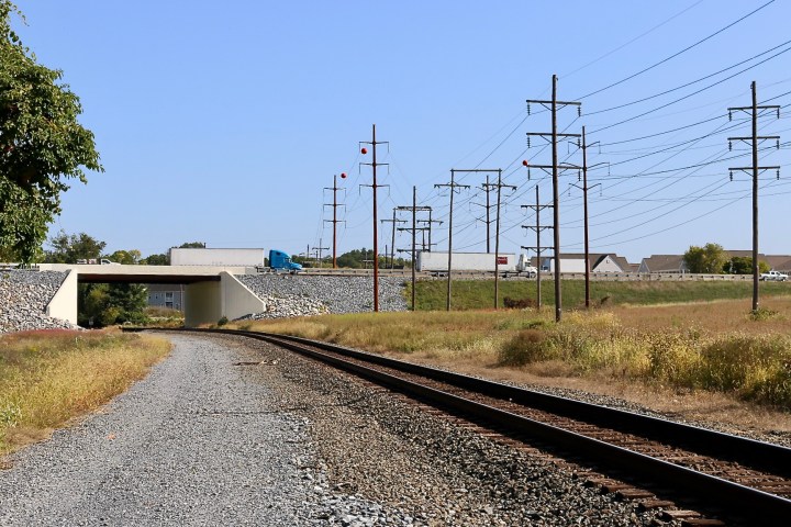
The Railroad
The path outside my front door leads along the pipeline right-of-way to the train tracks. It is a two-minute walk. The single iron track is a sharp slice in the landscape, cleaving the development in two. While the south side has been hammered into houses and is mostly settled business, the north side is being aggressively worked by earthmovers and dynamite as new sewers and roads lay the groundwork for the next phase.
The railroad has been here the longest. The line was originally built in the 1870s by the Harrisburg and Potomac Railroad. By 1895, the Philadelphia and Reading Railroad, at one time the largest company in the world, owned it. There is big money in infrastructure, which is proportional to its impact on landscapes. Pennsylvania and especially Harrisburg were shaped by the railroads of the 19th and 20th centuries.
The Lurgan Branch links coalfields, factories, and ports with growing cities in the southeast. It runs day and night hauling the freight that is the material manifestation of our modern economy. Shipping containers are links in the supply chain that enable our lifestyles. On some days I see entire trains loaded with coal heading south or empty hoppers making the return trip.
In the old days towns and railroads were connected in a symbiosis. Railroad towns grew where civic life and commerce depended on the local depot. But in my neighborhood the railroad and the village happen to be in the same space and have nothing to do with each other. Nonetheless, when the windows are open on a cool foggy night, blasts from the horns of passing locomotives shake the bed.
The Powerline
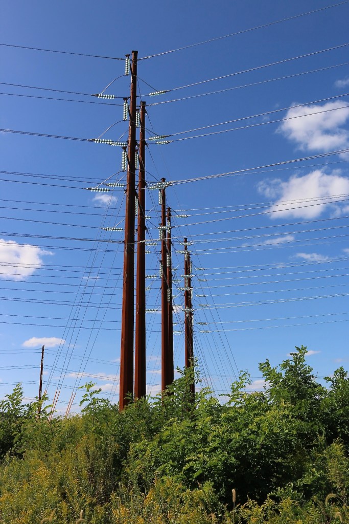
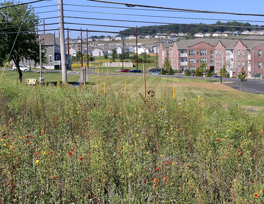
Next to where the train track crosses over the pipelines, at the edge of the development, is a massive electrical substation. There is something about electrical stations that is futuristic, all hard-edged and metallic. When we moved in it was already large. In the last three years it has tripled in size. New rust-colored towers guide ever more high voltage lines in. Most powerlines are regional infrastructure, but connect into a national grid. PPL Electric Utilities built this station to further serve the growing parts of the metro area because electricity is essential to modern cities. Nowhere is the tangled web of infrastructure more obvious than the wires heading into and out of this growing electric station.
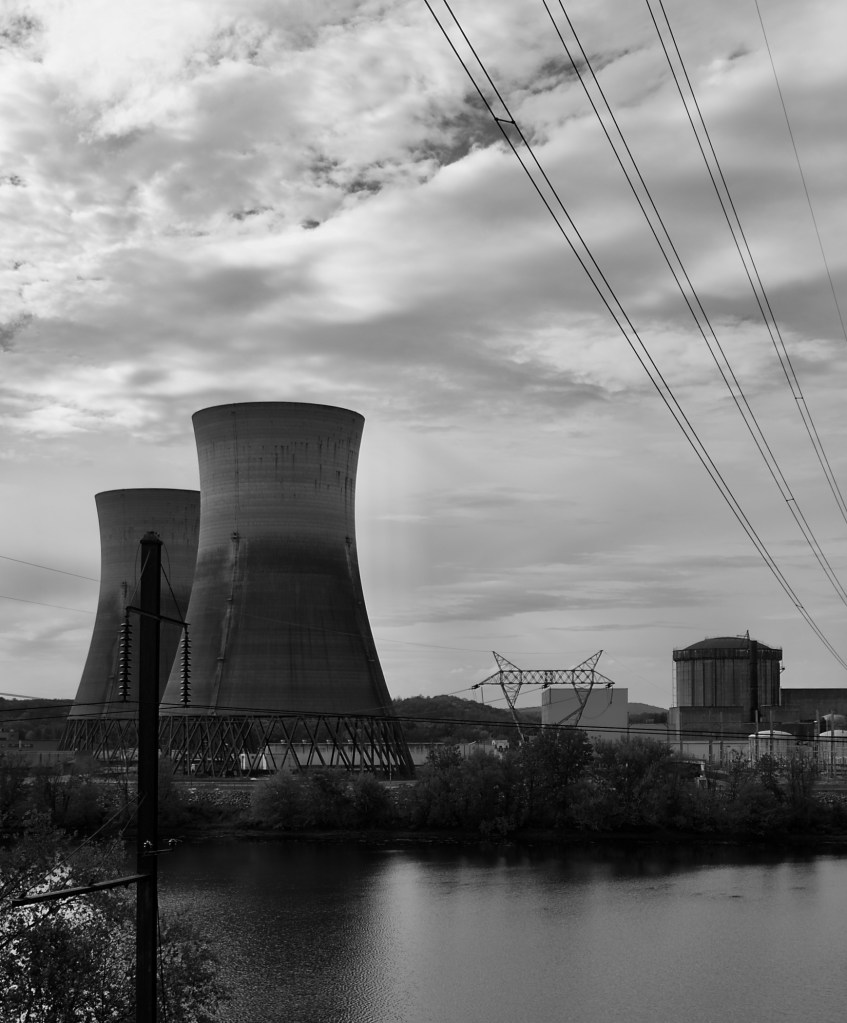
The power that came through here was originally supplied by the Three Mile Island Nuclear Generating Station ten miles east. TMI, as it is called locally, was actually two side-by-side systems on an island in the Susquehanna River. In 1979, Reactor Two famously malfunctioned after just three months of commercial operation in the worst civilian nuclear power accident in the United States. TMI1 continued to generate electricity until 2019, when it was shut down for cost reasons. Across the river from the sleeping nuclear plants, the Brunner Island Steam Electric Station burns fossil fuels and feeds the wires now.
Powerlines and substations are links and nodes. They cut the landscape into a tessellation — small polygons near cities, larger ones in rural areas. Cumulatively, they are a major land use in the country, most noticeably when they climb over a forested mountainside through a clear-cut right-of-way. But their biggest impact on landscapes is the electrification they bring for industry, for cooling and heating, and for all the machines of modern society. Without electric power, landscapes of America would be vastly different.
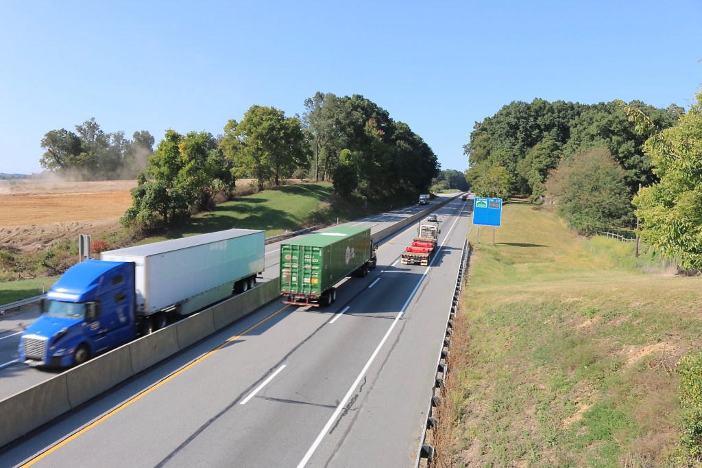
The Turnpike
Continuing on the our fifteen-minute tour, the Pennsylvania Turnpike forms a curved barrier around the top of the neighborhood. From my house there is an ever present low whistle of traffic. The turnpike was one of the first limited-access four-lane highways in the world. It was originally built to take advantage of abandoned rail tunnels under the Appalachian mountains in the 1930s, although the section here wasn’t built until 1950.
The Pennsylvania Turnpike was the model for the modern Interstate Highway System. It presaged an era of automobiles and trucks, democratizing trans-Appalachian commerce. Although a highway in every sense, it doesn’t have the width or rights-of-way of newer highways. Nonetheless, the turnpike, like all highways, makes a major impact on landscapes. Turnpike interchanges are access points and induce land development. Exit 236 is two miles away from my rapidly growing area. Of equal concern to me are the ecological impacts of the turnpike. Fences, guardrails, and murderous traffic are brawny barriers on the landscape.
Sitting in my front window I watch trucks and cars speeding by on the toll road and imagine exotic destinations and adventures. I love a good road trip. But in the middle of a pandemic, I bivouac in a house that someone thought would look more “traditional” with fake mullions on the windows. The effect is rather incarcerating. Someday I will get to explore far off landscapes again, but for now I find myself just humming a few bars of Willie Nelson.

[…] It is, however, a green dot in the nature network that stretches across the landscape. In “A Tangled Web,” I wrote about the engineered, hard infrastructure that creates networks, but there is another […]
LikeLike